

Geofences
Draw the places that matter and get told when a vehicle crosses one — circle or polygon, the sizing that stops false alerts, and dwell timings.
A geofence is a shape on the map. Once a vehicle is inside or outside one, Yipii can tell you — which turns "where was the van at 09:40" into "the van reached the school at 09:38".
The product labels these Geozones, and they live inside Alerts → Geozones rather than on a page of their own.
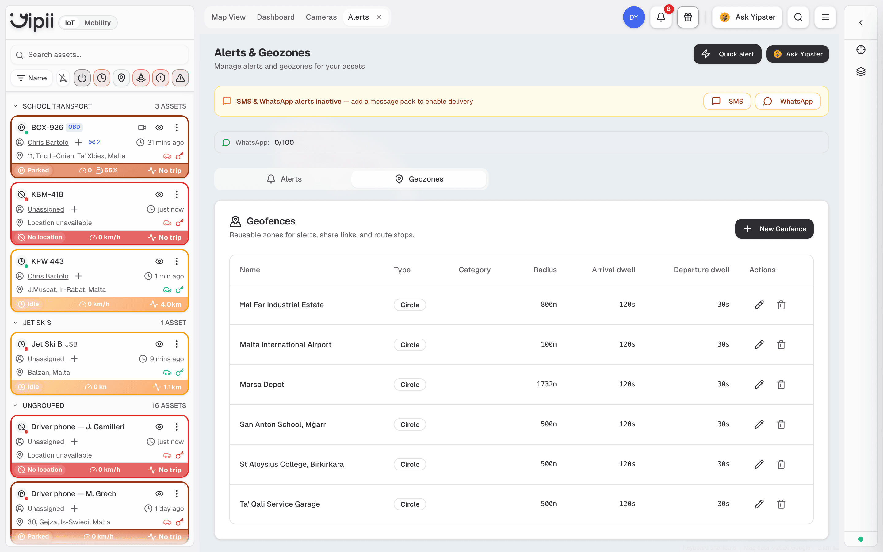
The two shapes
| Shape | Use it for | Needs |
|---|---|---|
| Circle | A site with a rough centre — a depot, a school, a customer | A pin and a radius |
| Polygon | An area whose edges matter — an industrial estate, a quarry, a restricted zone | Three or more corners |
Circles cover most cases and are quickest to draw. Reach for a polygon when a circle would either miss part of the site or spill onto a road that merely passes it.
Drawing one
Open Alerts, then the Geozones tab, then New Geofence.
Give it a name (1). This appears in every alert and report, so use the name your team already says out loud — "Marsa Depot", not "Zone 1".
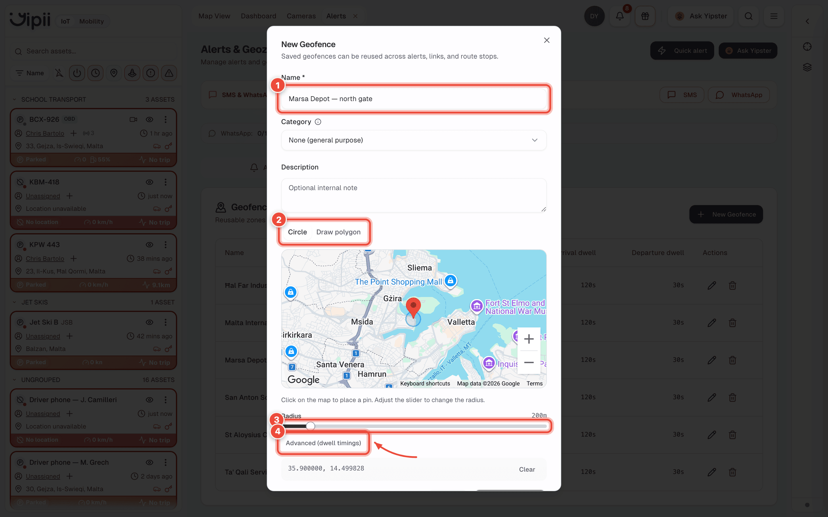
Choose Circle or Draw polygon (2). On Circle, click the map to drop a pin; on Draw polygon, click each corner in turn.
Set the Radius (3). Sizing is where geofences usually go wrong — see below.
Open Advanced (dwell timings) (4) if the site sits on a through road. Arrival dwell is how long a vehicle must stay before it counts as having arrived; departure dwell is the same on the way out. They default to 120 s and 30 s, and they are what stops a vehicle that merely drove past registering as a visit.
Create Geofence. It is now reusable across alerts, tracking links and route stops.
Category is optional and only affects grouping — a geofence with no category still works everywhere.
Sizing
This is where geofences usually go wrong.
- Too small and GPS drift makes a vehicle parked at the gate flip in and out, raising an alert each time.
- Too large and it catches vehicles that were only driving past.
A yard or a school gate is usually right at 100–250 m. An industrial estate or a port wants 800–1,000 m. If a site sits on a busy road, draw a polygon that follows the boundary instead of a circle that overlaps the carriageway.
Alerting on a geofence
A geofence does nothing on its own — an alert is what turns a boundary crossing into a message. Three alert types use them:
| Alert type | Fires when |
|---|---|
| Inside geozone | The asset is inside the shape |
| Outside geozone | The asset is outside the shape |
| Nearest geopoint | The asset comes within range of a defined point |
There is no dwell-time alert — no "tell me when a vehicle has been here for N minutes". Saved geofences do carry arrival and departure dwell settings, but those debounce arrival and departure detection (so a vehicle pausing at the gate isn't counted as arriving), they do not raise an alert. For how long a vehicle stayed somewhere, use the stops and point-visits reports.
Pair the alert with quiet hours, or a depot will alert every morning when the fleet legitimately leaves. Out-of-hours movement is the version worth waking someone for.
Where geofences show up
- Alerts — inside/outside conditions, per asset or asset group.
- Reports — arrival and departure per site, exportable to PDF or Excel for a customer or an invoice.
- Tracking links — arrival detection can expire a public link once the vehicle reaches its destination.
If it doesn't work
| Symptom | Cause | Fix |
|---|---|---|
| The same place alerts over and over | The geofence is small enough that GPS drift crosses the boundary while the vehicle is parked | Enlarge it, or move the centre away from where vehicles park |
| Nothing fires at all | The geofence was saved but no alert references it | Create an alert, then select this geozone and the assets it applies to |
| It fires for vehicles only driving past | A circle is overlapping an adjacent road | Redraw it as a polygon following the site boundary |
| A circle will not save | No pin was dropped, so there is nothing for the radius to centre on | Click the map first, then set the radius |
| A vehicle driving past registers as a visit | Arrival dwell is too short for a site on a through road | Raise Arrival dwell under Advanced (dwell timings) |
| Alerts arrive late | Crossings are evaluated on incoming tracker data, so an asset that reports infrequently crosses the line before Yipii hears about it | Check the asset is reporting on its tracker |
| Nothing happens while a vehicle is offline | Positions are only evaluated when they arrive | Expected. The crossing surfaces once the tracker reconnects |
Related
- Alerts — the rules that make a geofence do something.
- Reports — arrival, departure and time on site.
- Tracking links — arrival-based expiry for customers.
- Construction & plant — geofences as a theft alarm for site machinery.
Was this page helpful?